Bild 1 von 1
Galerie
Bild 1 von 1

Ähnlichen Artikel verkaufen?
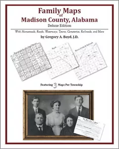
Family Maps Madison County Alabama Genealogy AL Plat

US $34,95
Ca.CHF 27,82
Artikelzustand:
2 verfügbar21 verkauft
- Sofort-KaufenFamily Maps Madison County Alabama Genealogy AL Plat
Oops! Looks like we're having trouble connecting to our server.
Refresh your browser window to try again.
Versand:
US $3,99 (ca. CHF 3,18) USPS Media MailTM.
Standort: Aubrey, Texas, USA
Lieferung:
Lieferung zwischen Mi, 5. Nov und Do, 13. Nov nach 94104 bei heutigem Zahlungseingang
Rücknahme:
30 Tage Rückgabe. Käufer zahlt Rückversand. Wenn Sie ein eBay-Versandetikett verwenden, werden die Kosten dafür von Ihrer Rückerstattung abgezogen.
Zahlungen:
Sicher einkaufen
Der Verkäufer ist für dieses Angebot verantwortlich.
eBay-Artikelnr.:170534738223
Artikelmerkmale
- Artikelzustand
- Subject
- Reference
- Topic
- Atlases
- ISBN
- 9781420315332
Über dieses Produkt
Product Information
Locating original landowners in maps has never been an easy task-until now. This volume in the Family Maps series contains newly created maps of original landowners (patent maps) in what is now Madison County, Alabama, gleaned from the indexes of the U.S. Bureau of Land Management. But it offers much more than that. For each township in the county, there are two additional maps accompanying the patent map: a road map and a map showing waterways, railroads, and both modern and many historical city-centers and cemeteries. Included are indexes to help you locate what you are looking for, whether you know a person's name, a last name, a place-name, or a cemetery. The combination of maps and indexes are designed to aid researchers of American history or genealogy to explore frontier neighborhoods, examine family migrations, locate hard-to-find cemeteries and towns, as well as locate land based on legal descriptions found in old documents or deeds. The patent-maps are essentially plat maps but instead of depicting owners for a particular year, these maps show original landowners, no matter when the transfer from the federal government was completed. Dates of patents typically begin near the time of statehood and run into the early 1900s. 326 pages with 92 total maps What's Mapped in this book (that you'll not likely find elsewhere) . . . 3986 Parcels of Land (with original landowner names and patent-dates labeled in the relevant map) 358 Cemeteries plus . . . Roads, and existing Rivers, Creeks, Streams, Railroads, and Small-towns (including some historical), etc. What YEARS are these maps for? Here are the counts for parcels of land mapped, by the decade in which the corresponding land patents were issued: DecadeParcel-count 1820s34 1830s1124 1840s189 1850s978 1860s185 1870s31 1880s188 1890s465 1900s164 1910s133 1920s261 1930s30 1940s17 1950s87 1960s76 1970s7 1980s5 1990s9 2000s2 What Cities and Towns are in Madison County, Alabama (and in this book)? Ashland, Berkley, Big Cove, Bobo, Brandontown, Bravo, Brookhurst, Browns Corner, Brownsboro, Buckhorn, Bucks Canyon, Burrows, Butler Mill, Carter Grove, Cedar Point, Chase, Chelsea, Cherrytree, Clarkdale, Cluttsville, Deposit, Dug Hill, Edgemont, Elko, Elkwood, Elon, Fairview, Fannings Crossing, Farley, Fisk, Gladstone, Greenfield, Gurley, Haden, Harvest, Hazel Green, Hillsboro, Hobbs Island, Hoover, Huntsville, Incline, Indian Hills, Jeff, Johnson, Keys Mill, Lily Flagg, Lincoln, Lincoya, Longwood, Lowe (historical), Madison, Madison Crossroads, Maple Hill, Maplewood, Mayfair, Maysville, McCaleb Mill, Mercury, Meridianville, Monrovia, Moontown, Moores Mill, Mount Lebanon, Nebo, New Haven, New Hope, New Market, New Sharon, Normal, North Daye Hill, Northwood, Norton, Oak Grove, Oak Park, Old Monrovia, Owens Cross Roads, Pea Ridge, Piedmont, Plevna, Rainbow, Ready Crossing, Ridgewood, Roseboro, Ryland, Saint Clair Store, Sandhurst Park, Sherwood Park, Skinem, Stag Run, State Line, Steele Crossing, Stone Ridge, Sublett Mill, Sulphur Springs, Terry Heights, Three Forks, Toney, Triana, Union Grove, Union Park, University Park, Vaughn Corners, Walker Woods, West Huntsville, Whitesburg
Product Identifiers
Publisher
Arphax Publishing
ISBN-10
1420315331
ISBN-13
9781420315332
eBay Product ID (ePID)
127050086
Product Key Features
Subject
Atlases, Gazetteers & Maps (See Also Travel / Maps & Road Atlases), Genealogy & Heraldry, General, Référence
Publication Year
2010
Number of Pages
326 Pages
Publication Name
Family Maps of Madison County, Alabama, Deluxe Edition : With Homesteads, Roads, Waterways, Towns, Cemeteries, Railroads, and More
Language
English
Type
Map
Format
Trade Paperback
Additional Product Features
Target Audience
Scholarly & Professional
Illustrated
Yes
Artikelbeschreibung des Verkäufers
Info zu diesem Verkäufer

arphaxpub
100% positive Bewertungen•4.9 Tsd. Artikel verkauft
Angemeldet als gewerblicher Verkäufer
Verkäuferbewertungen (2'090)
Dieser Artikel (3)
Alle Artikel (2'090)
- -***2 (848)- Bewertung vom Käufer.Letztes JahrBestätigter KaufTakes too long to receive... as they must use Amazon to print AFTER you order....
- o***f (437)- Bewertung vom Käufer.Vor über einem JahrBestätigter KaufArrived promptly in condition advertised. Happy with the purchase
- t***n (284)- Bewertung vom Käufer.Vor über einem JahrBestätigter KaufGreat resource
- t***t (1158)- Bewertung vom Käufer.Letzte 6 MonateBestätigter KaufBook was exactly as described. I contacted seller 10 days after purchase because it had not been shipped. Tracking number was provided within hours of my inquiry and the book was delivered by Amazon the next day.Family Maps Boone County Indiana Genealogy Plat History (Nr. 170534735414)
- a***d (313)- Bewertung vom Käufer.Letzter MonatBestätigter KaufGreat communication and lightening fast shipping.
- 7***7 (319)- Bewertung vom Käufer.Letzter MonatBestätigter Kaufquick delivery, good communication.
Noch mehr entdecken:
- Atlanten und Landkarten Hema Maps,
- Hema Maps Fachbücher, Lernen und Nachschlagen,
- Englische Atlanten und Landkarten Hema Maps,
- Fachbücher, Lernen und Nachschlagen Hema Maps auf Englisch,
- Hema Maps Ab 2010 Fachbücher, Lernen und Nachschlagen,
- Deborah-Madison-Kochbücher-Sachbuch Kochen Bücher auf Englisch,
- Deborah-Madison-Gebundene-Ausgabe - Kochbücher-Sachbuch Bücher übers Kochen
Verkäuferbewertungen (2'090)
Dieser Artikel (3)
Alle Artikel (2'090)
- -***2 (848)- Bewertung vom Käufer.Letztes JahrBestätigter KaufTakes too long to receive... as they must use Amazon to print AFTER you order....
- o***f (437)- Bewertung vom Käufer.Vor über einem JahrBestätigter KaufArrived promptly in condition advertised. Happy with the purchase
- t***n (284)- Bewertung vom Käufer.Vor über einem JahrBestätigter KaufGreat resource
- t***t (1158)- Bewertung vom Käufer.Letzte 6 MonateBestätigter KaufBook was exactly as described. I contacted seller 10 days after purchase because it had not been shipped. Tracking number was provided within hours of my inquiry and the book was delivered by Amazon the next day.Family Maps Boone County Indiana Genealogy Plat History (Nr. 170534735414)
- a***d (313)- Bewertung vom Käufer.Letzter MonatBestätigter KaufGreat communication and lightening fast shipping.
- 7***7 (319)- Bewertung vom Käufer.Letzter MonatBestätigter Kaufquick delivery, good communication.