Bild 1 von 1
Standardbild

Bild 1 von 1
Standardbild

National Geographic Reference Map Ser.: Africa - National Geographic by National Geographic Maps - Reference and National Geographic Maps Staff (2015, Sheet Map, Rolled)

grandeagleretail (947491)
98,2% positive Bewertungen
Preis:
US $39,05
(inkl. MwSt.)
Ca.CHF 31,58
+ $12,64 Versand
Rücknahme:
Artikelzustand:
- Sofort-KaufenAfrika Exekutive, laminiert: Wandkarten Kontinente von National Geographic Maps (E
Oops! Looks like we're having trouble connecting to our server.
Refresh your browser window to try again.
Über dieses Produkt
Product Identifiers
PublisherNational Geographic Maps
ISBN-101597752592
ISBN-139781597752596
eBay Product ID (ePID)204391338
Product Key Features
Number of Pages1 Pages
LanguageEnglish
Publication NameAfrica-National Geographic
Publication Year2015
SubjectEarth Sciences / Geography, Africa / General, Atlases, Gazetteers & Maps (See Also Travel / Maps & Road Atlases), Travel, Reference, Science
TypeMap
AuthorNational Geographic Maps-Reference, National Geographic Maps Staff
SeriesNational Geographic Reference Map Ser.
FormatSheet Map, Rolled
Dimensions
Item Weight3 Oz
Item Length30.8 in
Item Width24 in
Additional Product Features
Edition Number2015
Intended AudienceTrade
IllustratedYes
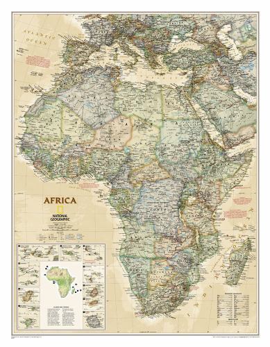
SynopsisExpertly researched and designed, National Geographic's Africa Wall Map is the authoritative map of Africa by which other reference maps are measured. Product Features: Antique-style "executive" color palette Background shows mountain ranges and valleys in subtle shaded relief with mountain ranges labeled Major water bodies including rivers, lakes, glaciers, oceans, seas, gulfs, bays, straits, and bathymetry Clearly defined international boundaries , cities, islands, airports, and physical features Thousands of place names carefully and artfully placed to maintain legibility in heavily populated areas Up-to-date international boundaries and territorial control reflect de facto status on the ground Meticulously researched using multiple authoritative sources including the United Nations and policies of individual governments. Accurate place names use a combination of conventional English names, official national names, and standard transliterations for non-Latin alphabets. Major landforms including deserts, lava fields, swamps, dry salt lakes, intermittent lakes, salt deserts, and areas below sea level Inset maps of the 10 island nations surrounding Africa and climate and terrain topographic map of the continent Countries shown include: Algeria, Angola, Benin, Botswana, Burkina Faso, Burundi, Cameroon, Cape Verde, Central African Republic, Chad, Democratic Republic of the Congo, Republic of Congo, Côte d'Ivoire, Djibouti, Egypt, Equatorial Guinea, Eritrea, Ethiopia, Gabon, Gambia, Ghana, Guinea, Guinea-Bissau, Kenya, Liberia, Libya, Madagascar, Malawi, Mali, Mauritania, Morocco, Mozambique, Namibia, Niger, Nigeria, Rwanda, Senegal, Sierra Leone, Somalia, South Africa, Sudan, South Sudan, Tanzania, Togo, Tunisia, Uganda, Zambia, and Zimbabwe. The island nations shown are: Canary Islands, Madeira Islands, Comoros, Seychelles, Mauritius, Rodrigues, Reunion, Sao Tome and Principe, Bioko, and Cape Verde. The map is encapsulated in heavy-duty 1.6 mil laminate which makes the paper much more durable and resistant to the swelling and shrinking caused by changes in humidity. Laminated maps can be framed without the need for glass, so the frames can be much lighter and less expensive. Map Scale = 1:14,244,000 Sheet Size = 24" x 30.75", National Geographic's map of Africa is as attractive as it is functional. The entire continent is rendered in the Executive style with an antique color pallet, clearly defined international borders, shaded relief, and easy-to-read fonts. Place names, bodies of water, airports, major highways and roads, as well as cartographic patterns used to depict sand, lava fields, swamps, dry salt lakes, intermittent lakes, salt deserts, and areas below sea level are shown as well. This map also includes an informative inset on climate and terrain with a topographic map of the continent and individual insets of the 10 island nations surrounding Africa. Coverage includes the following countries, their capitals, and major cities: Algeria, Angola, Benin, Botswana, Burkina Faso, Burundi, Cameroon, Cape Verde, Central African Republic, Chad, Democratic Republic of the Congo, Republic of Congo, C'te d'Ivoire, Djibouti, Egypt, Equatorial Guinea, Eritrea, Ethiopia, Gabon, Gambia, Ghana, Guinea, Guinea-Bissau, Kenya, Liberia, Libya, Madagascar, Malawi, Mali, Mauritania, Morocco, Mozambique, Namibia, Niger, Nigeria, Rwanda, Senegal, Sierra Leone, Somalia, South Africa, Sudan, South Sudan, Tanzania, Togo, Tunisia, Uganda, Zambia, and Zimbabwe. The island nations shown are: Canary Islands, Madeira Islands, Comoros, Seychelles, Mauritius, Rodrigues, Reunion, Sao Tome and Principe, Bioko, and Cape Verde. The map is encapsulated in heavy-duty 1.6 mil laminate which makes the paper much more durable and resistant to the swelling and shrinking caused by changes in humidity. Laminated maps can be framed without the need for glass, so the fames can be much lighter and less expensive. Map Scale = 1:14,244,000 Sheet Size = 24" x 30.75"

![AFRICA EXECUTIVE [LAMINATED] (NATIONAL GEOGRAPHIC By National Geographic Maps](https://i.ebayimg.com/images/g/85AAAOSwtO1naFTk/s-l225.jpg)


