Bild 1 von 1
Standardbild

Bild 1 von 1
Standardbild

National Geographic Reference Map Ser.: New Zealand - National Geographic by National Geographic Maps Staff (2019, Sheet Map, Rolled)

grandeagleretail (946983)
98,3% positive Bewertungen
Preis:
US $23,52
(inkl. MwSt.)
Ca.CHF 18,94
+ $18,26 Versand
Rücknahme:
Artikelzustand:
- Sofort-KaufenNeuseeland, geröhrt von National Geographic Maps (englisch) Kartenbuch
Oops! Looks like we're having trouble connecting to our server.
Refresh your browser window to try again.
Über dieses Produkt
Product Identifiers
PublisherNational Geographic Maps
ISBN-101597756334
ISBN-139781597756334
eBay Product ID (ePID)227761103
Product Key Features
Number of Pages1 Pages
Publication NameNew Zealand-National Geographic
LanguageEnglish
Publication Year2019
SubjectTravel, Reference, Science, Earth Sciences / Geography, Australia & Oceania, Atlases, Gazetteers & Maps (See Also Travel / Maps & Road Atlases)
TypeMap
AuthorNational Geographic Maps Staff
SeriesNational Geographic Reference Map Ser.
FormatSheet Map, Rolled
Dimensions
Item Weight5 Oz
Item Length30.2 in
Item Width23.5 in
Additional Product Features
Edition Number2019
Intended AudienceTrade
IllustratedYes
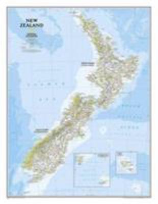
SynopsisThe reference map of New Zealand uses Expertly researched and designed, National Geographic's signature Classic style with blue oceans and stunning shaded relief. The map shows this island nation in great detail, from the subtropical North Island (Te Ika-a-Maui) to the glacial carved valleys of Fiordland on the South Island (Te Waipounamu). The North Island is best known for large volcanic lakes and the cities of Auckland and Wellington. The South Island is famous for the Southern Alps that run along the spine of the island. The highest point in the country is Aoraki (Mount Cook) and is found in the Southern Alps. The first settlers of New Zealand were the Maori from Polynesia, the names on the map reflect this history with both English and Maori variants. The map also features a transportation network including highways, roads, passenger railroads, and major airports. All National Parks are also shown. The map is packaged in a two inch diameter tube with a label showing a thumbnail of the map with dimensions and other pertinent information. Map Scale = 1:2,300,000 Sheet Size = 23.5" x 30.25", The reference map of New Zealand uses National Geographic's signature Classic style with blue oceans and stunning shaded relief. The map shows this island nation in great detail, from the subtropical North Island (Te Ika-a-Maui) to the glacial carved valleys of Fiordland on the South Island (Te Waipounamu). The North Island is best known for large volcanic lakes and the cities of Auckland and Wellington. The South Island is famous for the Southern Alps that run along the spine of the island. The highest point in the country is Aoraki (Mount Cook) and is found in the Southern Alps. The first settlers of New Zealand were the Maori from Polynesia, the names on the map reflect this history with both English and Maori variants. The map also features a transportation network including highways, roads, passenger railroads, and major airports. All National Parks are also shown. The map is packaged in a two inch diamater clear plastic tube. The tube has a decorative label showing a thumbnail of the map with dimensions and other pertinent information. Map Scale = 1:2,300,000 Sheet Size = 23.5" x 30.25"


